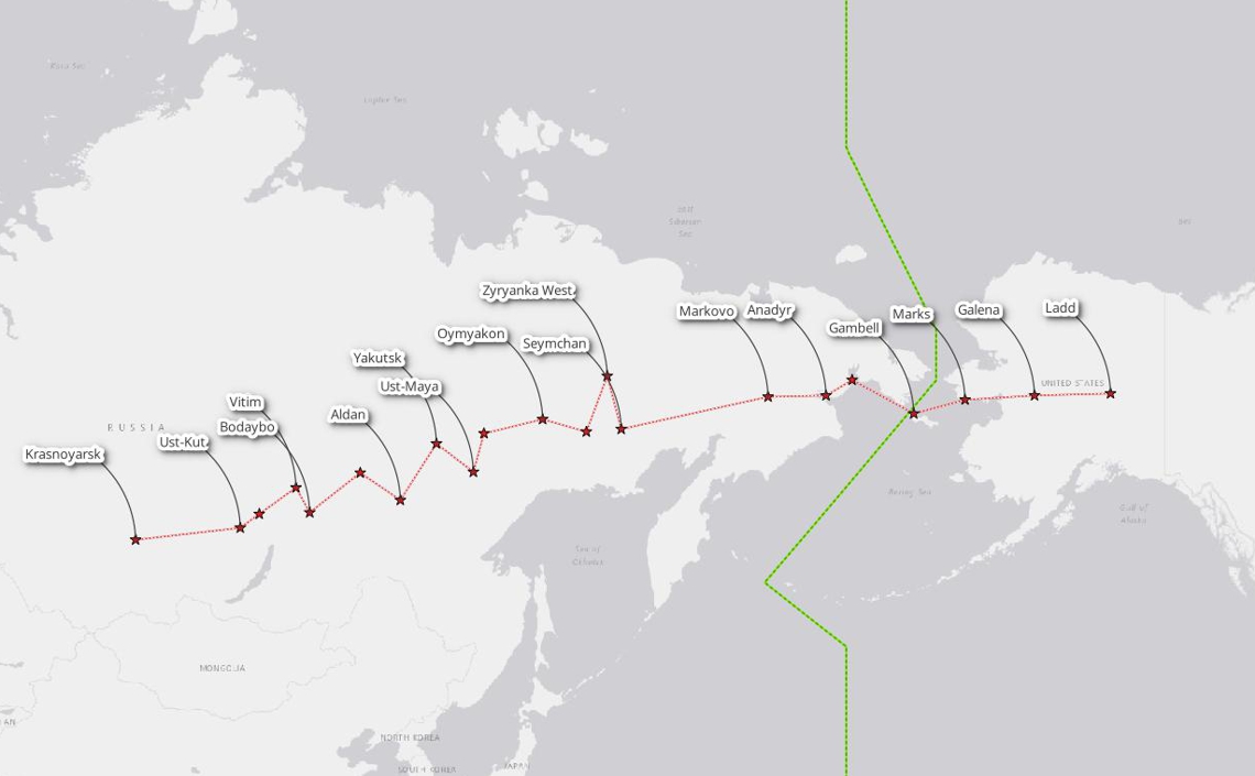
The main axis of the ALSIB route on its Soviet side runs from Ladd Field in Alaska to Krasnoyarsk. The map does not depict the dense network of branches extending north to the Arctic Sea and south to Kamchatka, China, and Mongolia. The American branch of ALSIB route, from Great Falls, Montana, to Ladd Field, is intensively studied by our sister association missing.aero as part of its search mission "AF-2469" (link here).
« ALSIB » - Alaska-Siberia Air Route, 1942
BackgroundThe ALSIB route was a crucial air ferrying route established during World War II – Great Patriotic War as part of the Lend-Lease program, in which the United States supplied military equipment to Allied nations, including the Soviet Union.
The route stretched over 14.000 kilometres, from Great Falls, Montana (USA), to Siberia, crossing Alaska and the Bering Strait into Soviet territory until Krasnoyarsk (URSS).
This route facilitated the transfer of American, Canadian and British-built aircraft to the Soviet Union to bolster its efforts against Nazi Germany on the Eastern Front. ALSIB was actively used between 1942 and 1945.
Over 8,000 planes were ferried along this route. Both American pilots (to Alaska) and Soviet pilots (from Alaska to Siberia) flew aircraft on harsh weather conditions, treacherous terrain, and limited navigation technology implying significant risks. A series of airfields and stopover points support the operations.
The operation symbolized cooperation between the USA and USSR during a critical phase of the war, despite ideological differences.
The ALSIB route remains a testament to the logistical ingenuity and international cooperation that helped secure Allied victory in WWII.
ALSIB
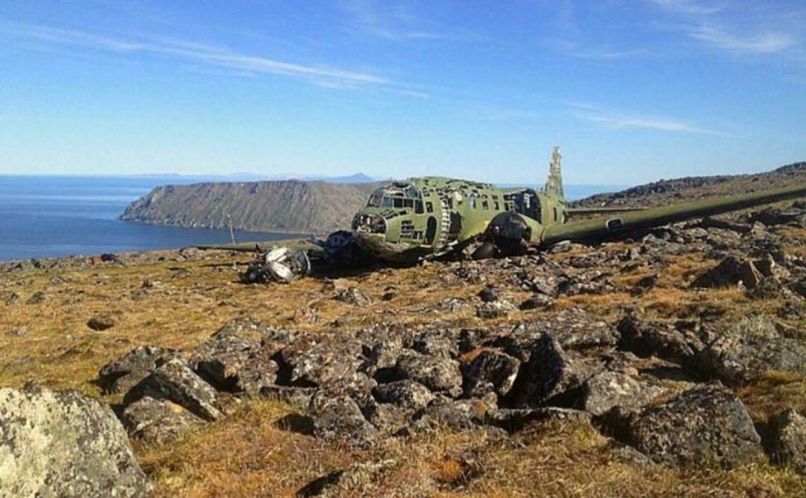
More than eighty planes were lost along this route by the end of World War II, known in Russia as the Great Patriotic War.
In 2020, the Russian Geographical Society (RGS), a non-profit organization that operates without government funding, launched the ALSIB project.
This initiative aims to conduct a comprehensive study of the airfields and history of the ALSIB route. The RGS's ALSIB project also includes efforts to search for, identify, and document airplanes that crashed or went missing within the territory of the Russian Federation.
The mission
The ALSIB route holds significant value for our research into Artificial Intelligence methods, including Machine Learning and Deep Learning, for locating wrecks of lost aircraft.
The first key factor is geomorphological: the route traverses tundra ("treeless land") and taiga (sparse boreal forest), which makes visual verification of wrecks identified by radar more feasible.
The second factor is the high potential density of aircraft wrecks; a single radar image may contain several wrecks within its frame.
Moreover, many of these wrecks have remained largely intact for over 80 years, offering an authentic and realistic scenario for studying lost aircraft detection.

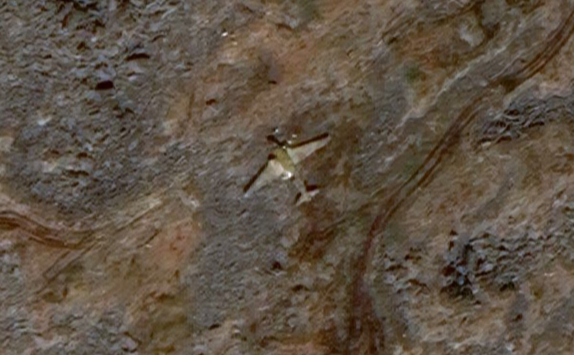
Under missed.aero radar: wreckage of the Lisunov Li-2T of the Soviet Border Troops (serial nd) crashed in Big Diomede Island - Ratmanov Island on June 13, 1971 (65.77828132, -169.06671593).